How Chicago Indians Became
Its 1st. Suburbanites
Just 150 years ago tomorrow, Chicago carved a city from the wilderness while turning the area's original American Indian landlords into the first suburbanites - moving them out of state.
Like today, prime real estate was downtown.
And the real estate war that launched Chicago into cityhood in 1837 was a real one: A series of battles that defeated Indian chief Black Hawk and his warriors in 1832. That allowed the federal government to pressure the Potawatomi Indians into ceding the last of their Chicago area land to the white man in 1833.
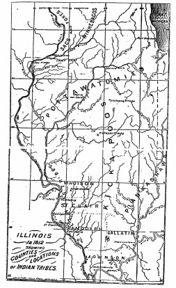
So as Chicago begins a series of activities this year to celebrate its incorporation, it's appropriate to look at the aea's Indian history—back to the 1830's, the decade of th city's birth. Ironically, Chicago now has many times the number of American Indian residents it had then. Some 3,600 Potawatomi lived in Illinois back in 1830, according to the editor of a recently published book on American Indians.
Now, the number of Indians in the city alone ranges from 10,000 to 20,000, she said. The book, Atlas of Great Lakes Indian History, is filled with exotic names of old or vanished Indian villages, the longest one being Shingabawassthekegobnwat, on Lake Huron.
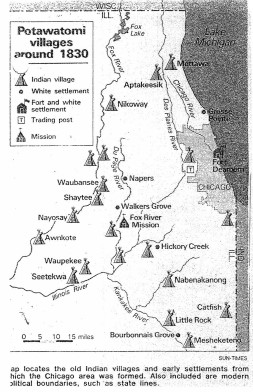
Editor Helen H. Tanner says the Chicago area drew Indians who travled the Straits of Mackinac and other wat:erways, often settling along rivers such as the Calumet, the Des Plaines, the Fox and, of course, the Chicago.
In fact, Indians stayed on longer in northern Illinois than they did Downstate, as whites moved into the Midwest
The white man whittled away Indian land around Chicago in 1816, when local tribes ceded lands within a strategic corridor that extended from the Illinois River, northeast to Lake Michigan between the present George Brennan Hwy., near .172nd Street in Tinley Park, and Roger's Avenue on the Far North Side (hence Indian Boundary Park).
Chicago's. Indian population today represents more than 100 differént tribes, with 23 organizations and programs centered on the North Side. They include the American Indian Center, the. Native American Education Service College, a credit; union andeconomic development association, programs of St. Augustine's Center for American Indians, and Little .Big Horn High School, a branch of Senn High School that official Board of Education directories, list only as the Indian branch of Senn.
The atlas by Tanner, a research associate at the Newberry Library, is being hailed by experts as a landmark in North American indian history. It's "a milestone. . . It should be something done for all all regions the country before its too late said University of New Mexico anthropoibgist Alfonso Ortiz of. the.10-year Chicago based project which was partly funded by The National Endowment for the Humanities.
Tanner and a team of historians pieced together accounts of early settlers, traders, missionaries, Indian agents, surveyors, military person and contemporary Indians to create maps of vanished and still existing villages, tribal distribution, battles, epidemics and land rights from 1640 to 1870.
The message that Tanner hopes will come through is that Indian and Indian history are still around us.
I'm just hoping that it is going to awaken an interest in Indian people so the general public will lose their idea that all Indians at on Sioux reservations or are Navajo" said Tanner.
The Great Lakes region, stretching. between St. Louis and Montreal, has more Indians living in it today than in the mid 18th century The atlas estimates the Indian population of the region in 1760 was 60,000 to 80,000, compared with nearly 300,000 today.
The $75 atlas—the Cartographer of which Miklos Pinther is chief cartographer of the United Nations—is generally out of stock said Tanner, but will be available later this month at the Newberry Library book store, with a. paperback expected out this summer.
Courtesy of Chicago Sun-Times March 3, 1987 ,Alf Siewers,| Copyright |