


Details
Object ID 004891
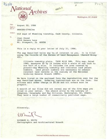
Object Name Old Maps Of Wheeling Township
Object Desc Old Wheeling Townshio and other maps ISee NOTES tab to view the documents. Source location in folder labeled "other documents" location unknown.
Collection Museum Collection
Accession # 20181123.190000.01
Alternate ID 99D23.3
General Category Documents
Category Documents - General
Source National Archives & Records
Source Category Society Property
Accession Date NOV 1,2018
Credit/Acknowledgement National Archives and Records Admin.
Location UNKNOWN
Object Date 1840
Start Year Range 1840
End Year Range
Status In Collection
Object Keywords 0000,Maps,Township,
Images
 (click for full image)
Image Caption
Description Illinois township plats. T42N R11E 3PM. This map, dated 1840, measures 20 by 16 inches with a scale of one inch to one half of a mile. It includes the area covered by present-day Wheeling township and indicates land patent numbers. Land patent numbers are necessary to consult relevant land records in the custody of the National Archives General Branch (NNFG).
Notes
Date DEC 22,2018
Notes Internal Use Only
Date DEC 22,2018
Notes To view the additional information, Please Click Here