Jeff Danna/Triblocal.com staff reporter
The story of Milwaukee Avenue is as much about the traditions and historical narratives that have defined the road for generations as it is about the continuous development and migration of various peoples along the route that keep it flourishing.
Although the communities that lie along Milwaukee Avenue vary in appearance, they all can trace their roots to the expansion of the road and the people who settled along it as they made their way north from the city of Chicago.
The road’s deviation from the Chicago-area street grid is due to the fact that it follows a centuries-old Indian trail. The trail cut through the territory ceded to the United States by various Indian nations with the Treaty of July 29, 1829.
“News of the 1829 Treaty reached England and probably convinced many Englishmen there would be much land available in the areas ceded by the Indians to the United States,” wrote the members of the Niles Historical Commission in the book “Niles Centennial History.”
During the 1830s, when white settlers were traversing what are today the northwest suburbs, the trail was little more than muddy ruts that ran northwest from outside Chicago’s Loop. The trail took no definitive shape—at some points, it was a mile wide—but its direction was clear.
The ruts were signs that the area northwest of the city was booming. The surrounding land was largely made up of farms—many of which were operated by German immigrants—and businesses like restaurants and hotels were popping up as the centers of communities.
For example, Niles’ origins lie near Milwaukee and Touhy Avenues, close to the north branch of the Chicago River, where in 1833 William Clark purchased a farm and the Ebinger family later settled. The first school was established nearby in 1837, the same year the first hotel, the North Branch, was built.
Similar activity was taking place several miles north in Wheeling.
“By 1836, Milwaukee Avenue, then known as Des Plaines Valley Road, had become a stagecoach route between Chicago and Green Bay, Wisconsin,” according to the Chicago History Museum’s “Encyclopedia of Chicago.” “This prompted Joseph Filkins to build a tavern and hotel at the corner of Dundee Road and Milwaukee Avenue.”
It was around this time that Cook County officials recognized the importance of the route to the viability of the region. According to documents provided by the Lake County Discovery Museum, and in September 1835, the County Commissioners Court of Cook County (which included present-day Lake County at the time) issued a directive to survey a road from Chicago to the Illinois-Wisconsin state line.
The starting point was Kinzie Street in Chicago, and the end point was the Green Bay Military Road at Illinois’ northern border. The road passed Dutchman’s Point (present-day Niles), Indian Creek Timber Road (now called Half Day Road), Wynkoop’s Point north of Libertyville and the Des Plaines River at Gurnee. Milwaukee Avenue was Lake County’s first state road.
With all the development taking place north of Chicago and the demand in the city for produce from the farms, it was only a matter of time before the route became modernized.
Beginning in 1849, the road was paved with wooden planks and named, appropriately, Milwaukee Plank Road. Two-by-fours were laid across a 16-foot wide graded path, and 8-foot planks were laid down the middle, creating a raised road with walking paths on each side.
The plank road was built privately, and toll gates were installed along the route. Between Chicago and Wheeling, toll fees would total $1.30, including a 35 cent toll at Dutchman’s Point (Niles), according to information from the Glenview Historical Society.
Local historical accounts of the plank road era largely describe Milwaukee Plank Road as a failure, and according to the authors of the Wheeling Historical Society’s oral history book, “Wheeling Through the Years,” planking never extended beyond Niles.
“The plank roads were largely a disappointment,” according to a Glenview Historical Society document. “The roadbed did not drain well; the planks tended to float; the consequent slippage created airholes which hastened decay. Farmers sometimes stacked up the planks in flood times. The owners had paid too much of the profits in dividends without sufficient reserve for repairs, and within about ten years the plank road building craze was over.”
In the 1850s, a new owner of the road began rebuilding it with a gravel surface. As the century went on and more of the road was paved, land values and real estate prices along Milwaukee Avenue skyrocketed.
Businesses thrived along the road through the early 1900s—restaurants, taverns, hotels and other mom and pop establishments—even though the road’s condition left much to be desired to some residents.
In an Aug. 29. 1920 letter to the editor in the Chicago Tribune, available on Libertyville’s Cook Memorial Library Web site, a local resident complained about the “unspeakable ten miles of drainage ditch they call a road north of Wheeling.”
“Let the motorist who leaves Cook county concrete and ventures north through Half Day and Libertyville bid farewell to all he holds dear under his hood,” the resident wrote. “The startling part of the Illinois disgrace comes when one reaches the Wisconsin line. … On the Illinois side lie the chuckholes, broken springs, and buried hopes of a thousand sufferers. On the Wisconsin side, one foot ahead, lies perfect graded highway, smooth, well kept, delightful.”
In 1923, paving of the road was completed, and the event was cause for celebration.
“They had a street party when it was completed,” recalled Wheeling resident Lucile Schneider in “Wheeling Through the Years.” “They had a big shindig, like a grand opening, and they had a street dance and all of that, you know.”
By 1927, the newly-paved highway already had developed a congestion problem. The Cook County Board was already debating whether to widen Milwaukee Avenue, and Cook County Board President A.J. Cermak and Libertyville Village President Earl Corlett argued whether some stoplights should be removed in downtown Libertyville to speed up traffic flow, according to a Chicago Tribune account available through the Cook Memorial Library.
In April 1930, the Chicago Daily Tribune reported that the Lake County residents in favor of a $1.25 million bond issue for the paving of 37 miles of roads over four years in an effort to alleviate congestion along Milwaukee Avenue.
By the mid 1900s, though, expressways were being built throughout the Chicago region, allowing people in the ever-growing suburbs faster access to Chicago. With the construction of the Kennedy, Edens and Tri-State expressways, Milwaukee Avenue lost its stature as a major highway into the city.
But it continued to serve as a major local business corridor with restaurants, shopping centers and entertainment venues. In a more auto-centric era, development along Milwaukee Avenue took on a different look.
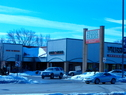
In the 1950s, the Village of Niles annexed land around Milwaukee Avenue and Golf Road for the construction of the Golf Mill Shopping Center, which opened in 1959.
Further north in Lake County, farmland was being transformed into shopping malls and subdivisions. In 1970, Vernon Hills’ population was a little more than 1,000, and the community had a shortage of commercial activity. But a year later, the village annexed property at Milwaukee Avenue and Illinois Highway 60, like Niles, for the construction of a shopping mall.
When Hawthorn Center opened, the village was able to eliminate property taxes for residents. The population subsequently grew to nearly 10,000 in 1980 and more than 20,000 by 2000, illustrating that despite the changing face of the region, Milwaukee Avenue continues to be an integral part of the Chicago area’s infrastructure and local communities. By Jeff Danna
TribLocal.com reporter
Historic photos submitted by the Wheeling Historical Society.
Present-day photos by Jeff Danna. |

 The Wheeling State Bank, right, stands at Milwaukee Avenue and Dundee Road. The building was built in 1927, but no longer eixists
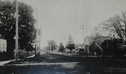
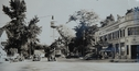 A historic photo depicts August Piper's blacksmith shop, which opened in 1908 on Milwaukee Avenue in Wheeling. The business was converted into a garage.
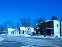
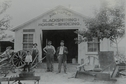 Fresh Farms International Market stands today where the 1927 Wheeling State Bank once stood.